Sunday, September 30, 2012

Walk Notice - Cranbourne Botanic Gardens - Saturday 6th October

Walk:

This venue had been chosen to enable all Walkabouters to take part.
Some can start by exploring part of the untouched heathy woodland 
and wetland of the 363 hectare site and climb to Trig Point Lookout 
for a 360 degree view.

The diverse remnant bushland represents a rare glimpse of the type of vegetation 
that once covered much of Western Port and Port Phillip Bay regions.
After exploring the Australian Garden and Visitors Centre we will return to 
the Stringybark Picnic Area.

Others might like to just meet us at the Australian Garden.

Grade:

Easy walking


No, this is not a beach walk. Although, there will be red sand and water
and lots of native flora and fauna.


Looking forward to seeing you there!


To join us on this walk, contact walkabouters@hotmail.com


Walkabouters Club of Victoria Inc.
A0019863A


Sunday, September 16, 2012

Richards Tramline, Warburton, Yarra Ranges - Sunday 16 September


Today five Walkabouters met in Warburton and ventured out to Big Pat's Creek. 


We parked our cars at the Picnic Ground just off Smythes Creek Road not far
from the junction of Mississippi Road in Big Pats Creek.

At this small picnic ground, two walking tracks lead off into the tall mountain ash forest. The Upper Yarra Walking Track or Walk into History track, follows the creek
south for 9 kilometers to Starlings Gap. This track was once the old Federal Tramline that was built in 1933 from Big Pat's Recreation Reserve to Starlings Gap.


The second walking track is Richards Tramline. This track follows the tramline
that was constructed by William Richards in 1916.

This was the track that we walked today.

What on earth were all these tramlines doing out in the forests of the
Upper Yarra Ranges?

Well, they weren't for carting people to shopping centres.

These tramlines were built to cart logs and timber from sawmills that were established deep in the forests, to the trains in nearby Warburton. The tall Mountain Ash eucalyptus trees were prized for building materials for the many houses being built in Melbourne in the early 1900's.  

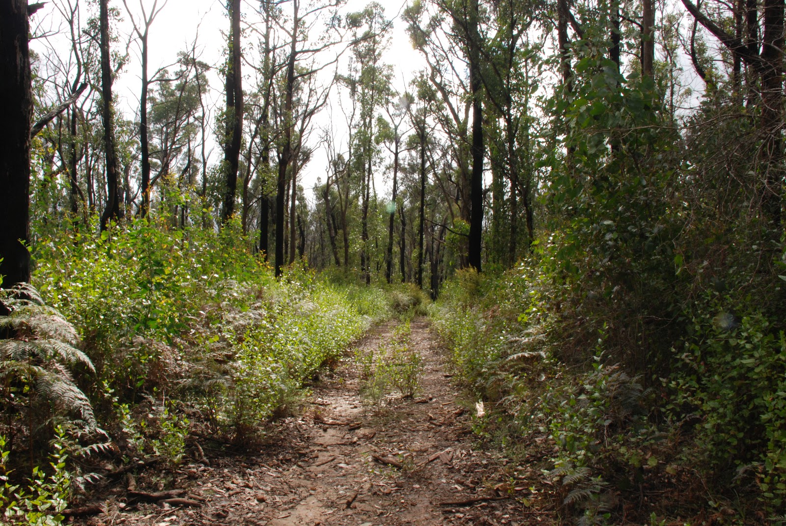
We walked along the track that was once Richards Tramline as it gradually made its way up the mountain side towards Starvation Creek Valley. It felt easy walking along the slight gradient of the tramline but we were soon met various obstacles that proved rather challenging.

Richards had many challenges when he built his tramway too!
To avoid the fees charged by local land owners, Richards constructed several
very tight curves on one section of his tramline.

We just had to clamber over and under a few fallen trees.


 He also build two very deep culverts which we splashed our way through as they had turned into very large puddles stretching about 20-30 metres.


Gumboots would have been very handy! 


The cool, damp hillside provided the perfect shelter for stands of fern trees.


Sign posts along the route that provided information 
about the history of the tramline.


There did not seem much to be left of the tramline other than the trail that meandered through the trees as it made its way up the hill side.


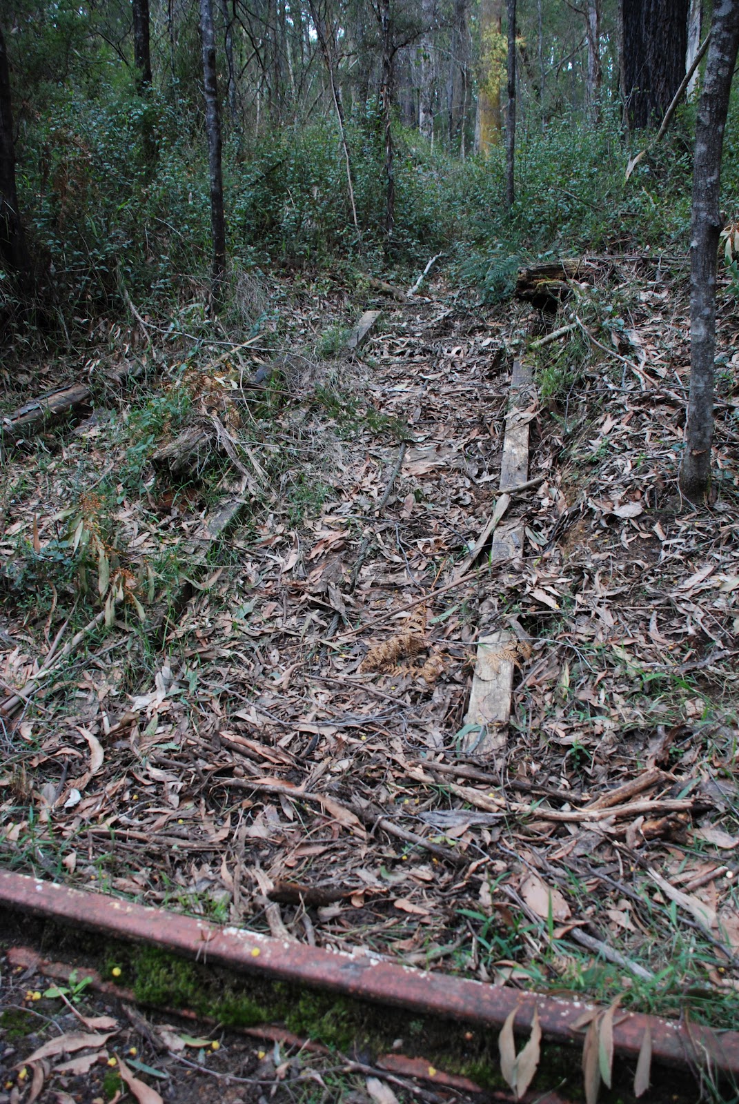
When suddenly, out of nowhere, these tracks appeared in the middle of the path!


Richards had us going in all directions! 


 There were wooden tracks coming down hill meeting the metal rails 
at a complete right angle!


After morning tea we continued along the tramline and made our way gradually into the Mississippi Creek Valley.


The sign on this tree told us that the tree had been struck by lightning.


We moved on from the lightning tree and came across some bushland that had recently undergone a controlled burn. 


 The blacken tree trunks and bare undergrowth was in stark contrast to the lush green forest we had just been walking through.


As we continued along the path, we could see the remnants of past bush fires.


Young wattle trees were is full flower amongst the blackened tree trunks.


We clambered through the branches of a fallen tree


and around just one more corner as the crow flies,
we had made it to our lunch destination.


A recently completed shelter provided an excellent spot for lunch.


The sign told us about the Mississippi Mills that were once located nearby.


We would have enjoyed a long leisurely lunch if it weren't for the blow flies that seemed to flying around for no reason. But enough said about that. After we had eaten enough and sat enough, we headed back down hill following the same path we came up. 


So, instead of backwards photos, here are some old photos that show Richards Tramline and Richards Mill from a by-gone era.

source: http://nla.gov.au/nla.pic-an24493528

This old slide, courtesy of the National Library of Australia, shows a bridge being built along a section of Richards Tramline.


These following photo are courtesy of the Light Railway Research Society
of Australia Inc. and show Richards Mill as it was in the 1960's.


Still working!


An old tram truck almost overgrown.

Many tramlines and sawmills were destroyed in the devastating bush fires of 1939. Much of the infrastructure was not rebuilt, as engine driven trucks and lorries replaced the horse driven and pulley systems of the old tramlines.

Richards Tramline it's self disappeared into the bush and was not rediscovered until after the Ash Wednesday fire in 1983. A local friends group and Parks Victoria have maintained Richards Tramline track, allowing it to be enjoyed by historians and walkers alike. 


We certainly enjoyed our walk through history.


Oh, almost forgot. Here is the link to the stats of the walk.
The walk was over 15 kilometers in total and we ascended about 200 meters.
We were very glad it was all downhill after lunch!

For more information about the Light Railway Research Society of Australia Inc.
follow this link 


Walkabouters Club of Victoria Inc.
A0019863A

Sunday, September 9, 2012

Walk Notice - Richards Tramline - Sunday 16 September

Walk:

Richard’s tramline was built in the early 1920s to transport timber down to the sawmills. We will follow the tramline up from the Big Pats Creek Picnic Area, passing "The Curves", a series of bends, cuttings and embankments which carried the tramline into the Big Pats Creek valley. We will then continue along the tramline up the Mississippi Creek valley, through tall mountain ash forests, and, after lunch, return to the picnic area.

Grade:


Medium walking on an old tramway, about 12 km in length, with options for shorter walks.


Bunyips aren't the only things that can be found in the Australian bush.

Tramlines also appear out of nowhere! 


Richard had a strange sense of humour!


Looking forward to seeing you there.

Don't forget your gumboots!


For information about the Walkabouters,
contact walkabouters@hotmail.com


Walkabouters Club of Victoria Inc.
A0019863A

Sunday, August 26, 2012

Andrews Hill, Kinglake National Park - Sunday 26th August

Today six Walkabouters walked up a hill. 

Who's hill? Andrews Hill, in Kinglake National Park.


It is only two and a half years age since the devastating bushfires that destroyed much of the forest and townships in and around Kinglake National Park. Many of the local communities are still struggling to recover and rebuild from this traumatic event.

 We decided it was time to visit this well known National Park 50 kilometers northeast of Melbourne to see how the bushland is recovering from the bushfires.


We met early in the morning at the Island Creek Picnic Ground in the
Wombelano Block of Kinglake National Park. The effects of the bush fires
were very evident. New signage and picnic tables had been built to replace
what was lost to the fire. 


The bridges had also been replaced which was good,
otherwise we would have got really wet!


As we walked through the forest, we could still see evidence of the bush fires. Most of the eucalypts had blackened trunks and some were like skeletons.


 However, it is wonderful to see how much the bush is in the
throws of regeneration. The lower story of the forest was thick with
wattles, goodenia and grass trees.


 Eucalyptus trees were shooting new leaves and branches along their trunks
and many new saplings were stretching young foliage towards
the sun after shooting from seeds that were set in motion
from the heat of the fire.


 We walked along Blackfish Way which followed the Blackfish Creek.
We didn't see any Blackfish.

Crossing the Kinglake-Glenburn Road we commenced our climb
up Andrews Hill following Andrews Hill Track.


It's just around the next corner, honest?!

Nearly there!


And we made it!

Ian pointed out that if we did that climb ten times, we would have walked
the distance from sea level to the top of Mount Fuji in Japan.

No one wanted to join Ian in this feat.


Once we were at the top, we had lunch!


 After lunch, it was all downhill.


 We walked along Dusty Miller Track named after the indigenous,
prolifically growing shrub not the popular singer from the 70's.

Oh, that was Dusty Springfield, whoops.


There they are, all the way down there!

This track finished at a T intersection with Mountain Creek Track.


 Turning right onto Mountain Creek Track, we walked to the next
junction with Stringybark Track.


Eucalyptus saplings amongst blackened trunks


 After inspecting the sturdiness of the new metal signs, we took a right hand
turn onto Stringybark Track which we followed back
to the Island Creek Picnic Ground.


It is screwed on!


The sun shone through the young leaves of the gum trees, 
creating a lovely afternoon glow as we walked through the regenerating bush.


 It wasn't long before we were back at the picnic ground 
enjoying a well earned cup of tea, tim-tams and teady bear biscuits.
(Thank-you Angela!)


Don't fall in!


 It was a great walk and wonderful to see that life can return after such devastation.

Click here for the stats of the walk. 
In brief, we walked 12 kms and reached a breathing taking altitude 625m 
and enjoyed ourselves immensely.


Walkabouters Club of Victoria Inc.
A0019863A


Sunday, August 19, 2012

Andrews Hill, Kinglake - Sunday 26 August


The Walk:

We will return here to see the how the area has recovered from the Feb 2009 fires. The walk is a loop from the picnic area, downstream along the creek for about 2km, a climb to the top of the hill and then it is downhill all the way back to the cars. The area is good for wildflowers and has many tall trees. The picnic area at Island Creek has been rebuilt with new toilets, signboard, paths and fences.

Grade:

This is a walk of about 11km on paths and tracks, with a moderately step section as it climbs 320 metres to the summit of the hill. For those not wishing to do the complete loop, there is the possibility of short walks from the meeting place.


Walking in Winter!


It's Saturday. No, it's Sunday. No, it's Saturday. NO! It's Sunday!! 
I will double check. Okay, yes, it's Sunday.

See you all on SUNDAY the 26th of August for a walk up Andrews Hill.

Hopefully it wont be too muddy!!


 For more information about the walk please email
 walkabouters@hotmail.com


Sunday, August 5, 2012

Boar Gully, Brisbane Ranges, Saturday 4th, August


We met in Bacchus Marsh in bright sunshine, after a wet drive, and drove
to Boar Gully Campground in the Brisbane Ranges National Park. After a
bit of stumbling around trying to find a path which had vanished in two
weeks, we set off to explore the North East corner of the park. 
We walked Farm Track, Spring Creek Track, Loop Track and on Hare Track,
where we met a furry friend (not a hare - see photo). 


Not a hare!

Then onto Bluff Tk, with kangaroos bounding off through the forest
and a wedge-tailed eagle circling low overhead, inspecting us.

Back to Loop Track, with a large stand of grass trees (see photo)

Grass tree
 

and onto Glider Track, with wattles whose bright yellows stood out amongst
the brown stringy barks (see photo of Acacia pycnantha - of Australia's floral emblem).

Acacia pycnantha amongst stringy barks

Close up of Acacia pycnantha

These tracks all run along the edge of the Spring Creek gorge, with views
across to distant hills. At a little dam on Loop Track, we had lunch
(see photo of one member of the group).

A Walkabouter!


Walkabouter's Picnic Point


Back across Reids Rd and down Pea Track to Aeroplane Rd, where we talked about the air force pilot who crashed here in Dec 1936, was badly injured
but was rescued and recovered after months in hospital. 
Then onto Oblique Tk, where the leader gave the compulsory botany talk, this one on the different types of eucalyptus bark, at a spot where a number of species
(stringy bark, box and ironbark ) grow together.


The track


We speculated as to whether the track
was named after the asymmetrical leaves of the messmate stringy bark, a
sample of which just happened to be lying on the track. Then on to Old
Thompson Rd and back to Boar Gully for a cup of tea. The total walk was
about 16km of relatively flat terrain.


Walkabouters Club of Victoria Inc.
A0019863A

Related Posts Plugin for WordPress, Blogger...